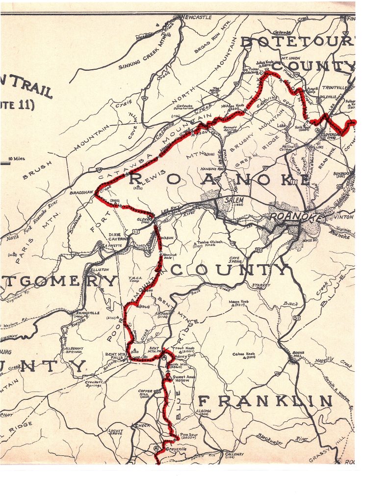
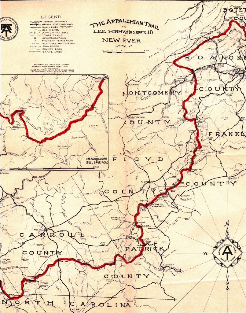
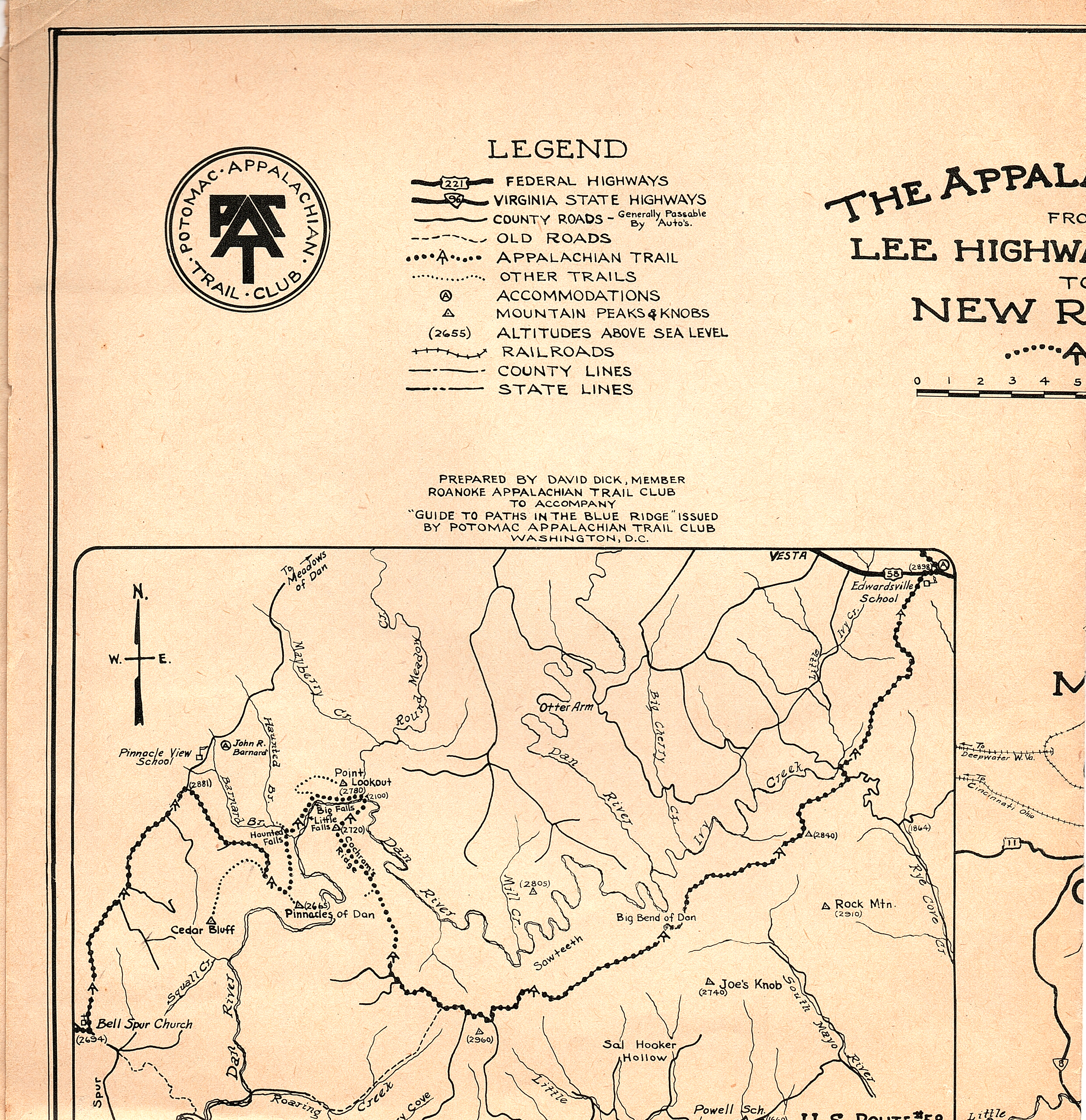
RATC Trail Supervisor David Dick's 1933 map ~ section around Roanoke
When the RATC was founded in November 1932, one of the first tasks was to finalize an A.T. route around Roanoke. The initial pathway marked in 1931 was not satisfactory to the hikers of RATC, and they convinced ATC leader Myron Avery to drop down from the Blue Ridge at Black Horse (Tavern) Gap, cross U.S. 11 near Daleville, and climb Tinker Mountain for a tough hike and outstanding views. Avery agreed and took the train from Washington, DC several times in 1933 to oversee completion of the new Trail. Avery’s PATC’S 1934 Guide to the Paths in the Blue Ridge touted the new route, sayin that: “Except for the Pinnacles of the Dan, Tinker Mountain is the outstanding feature of the Trail from the Natural Bridge National Forest to New River.”
David Dick, one of RATC’s founders and a certified surveyor, was the RATC’s first Trail Supervisor, and he also drew the first map of the A.T. from the Roanoke Valley to New River in 1933 at Avery’s request. As Dick reported at the end of the year, the map was printed by the PATC and sold as a fund raiser by both the PACT and the RATC.
Here is how Dick reported the work completed in 1933:
[Transcribed by Diana Christopulos, March 20, 2020]
Annual Report of the Trail Committee
Roanoke Appalachian Trail Club
November 12, 1933
The Trail Committee during the past year has been primarily concerned with the location, the measuring, and obtaining the trail data for our section of the Appalachian Trail. The first problem that confronted us was the general location of the trail. The trail was originally located south of Roanoke – from Villamont along the top of the Blue Ridge, past Mason Knob to Adney Gap on Bent Mountain. This trail had been measured but not very definitely marked, and it would in a good many instances require a complete relocation. Considering this and also that there are few points of outstanding interest on the southern route, it was suggested and approved by the club to locate the trail along the more interesting route north of Roanoke. This has been done with the help of many of the members not on the committee.
A number of hikes were made by various members of the committee and the club to determine the best location for the trail along the northern route. In locating the trail we considered points of interest, viewpoint, accessibility, grade of the trail, and maintenance necessary to keep the trail definitely marked. At very few places we were able to satisfy all the requirements. Some of the trail will be more difficult to follow until it is more suitably marked and cleared; some of it is steep, other portions offer nothing of interest and in such cases generally follow automobile roads and serve only as connecting links. As the trail is now located there are about 25 miles of automobile roads. Some may be changed so as to cover a more interesting section whenever the other trails are suitably marked and cleared.
Mr. Myron Avery assisted by various members of the committee and the club measured and obtained the trail data for our section of the trail on April 1st, 2nd, 29th and 30th. We also assisted Mr. Avery in measuring, obtaining trail data and marking 33.7 miles of trail from Bent Mountain Post Office to Tuggle Gap in Patrick County. As there is no organization to the care of this section it was routed along existing automobile roads and so requires no maintenance, other than a remarking once a year.
The success of these trips were greatly due to our President who, aside from his other duties, accompanied us on many of the hikes and used his car on most of these occasions. Others whom I believe are due special recognition are Dr. McGinnis who used his car frequently on trips and the Pownalls who accommodated Mr. Avery the two nights he was in Roanoke.
Two short sections of the trail have been marked. 6.80 miles from Black Horse Tavern Site to the county road and 1.2 mile along the road up Tinker Mountain. This is barely a beginning of the trail marking and making in our section. Mr. Avery has made some good suggestions on what should be done on this line. Our entire section should first be marked so that the blazes can be easily followed from end to end. Care should be taken to see that the trail as marked is exactly as described in the trail data. To do this a copy of the trail data should be used in the field while marking, and a member of the measuring party should be present. Where the trail follows roads passable by automobile the route can be marked by using a car. After the trail is entirely marked it can then be improved, where necessary by clipping the underbrush, etc. It will be clearly seen that the initial marking of the trail must not be delayed long lest we have difficulty following the route described.
As a general summary, our section of the trail is 68.29 miles long all of which has been measured and the trail data obtained. 8.0 miles have been marked leaving a balance of 60.29 miles to mark.
David Dick, Chairman
Report on Map
At the request of Mr. Avery I made a map of the section of the trail from Lee Highway [US 11] near Cloverdale to New River, for the Potomac Appalachian Trail Club’s new Guidebook. The Potomac club has had 900 copies printed at a cost of $30.00 from which they sent us about 300 copies. I have incurred an expense of $2.50 in making this map which I feel should be borne by our club. Mr. Avery suggested that these copies sold at 25¢ would bring in considerable revenue for paint, markers, etc.
[Note: the RATC archive includes 3 copies of this map in 2 slightly different versions. The archive also includes a February 1939 article from the Roanoke Times, “Mountain Trails Call Score of Roanokers to Open Each Week End,” that features the same map and a detailed discussion of RATC and its section of the trail. DC]
David Dick
RATC volunteers helped Avery and volunteers from other areas complete the Trail all the way to New River, near Galax, and Dick drew the first official map of the route. It is shown below, along with an excerpt from the upper left portion crediting Dick with creation of the map. The full map and the portion showing Dick’s name are below.
David Dick’s 1933 map of the A.T. from the Roanoke area to the New River, drawn at the request of Myron Avery and published by the Potomac Appalachian Trail Club in 1934
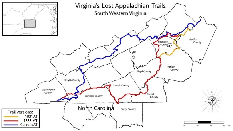
For comparison, the map below shows the 1931 (yellow), 1933 (red) and present (blue) route of the A.T. in southwestern Virginia.
Source: “Virginia’s Lost Appalachian Trail,” Mills Kelly, 2023
On September 30, 2021, officials from Roanoke County, the Virginia Tech Catawba Sustainability Center (CSC), the Roanoke Valley Greenway Commission and other organizations cut the ribbon to open the new Catawba Greenway. Hikers now have two additional parking locations for a McAfee Knob hike and a four-mile loop hike that connects two portions of the Catawba Greenway via the Appalachian Trail. AT thru hikers can now resupply at the Catawba Post Office without walking down busy State Highway 311 as well.
You will notice that I am referring to the Appalachian Trail as a Project. That is what it is in its present stage. Some of us look upon the Appalachian Trail as a completed trail. In fact it has been measured and blazed over its entire length and guide books printed to cover the entire trail. Such a situation may give the impression that the trail is completed, but it is far from completion.
It is safe to say that the section southwest from Roanoke to Iron Mountain near Damascus is the worst to be found in the whole length of the trail. . . I defy anyone to find anything of interest to the hiker except short stretches such as in Rocky Knob Park and The Pinnacles of Dan, and the Fisher’s Peak Area. These spots stand on their own merits, but they are connected by roads, mostly dirt but some graveled and paved. All wilderness aspect is lost. The very nature of this section detracts from the use of the trail.
In view of this situation, I have attempted to revive interest in a relocation project to get the trail moved to the West. This trail would, as presently planned, leave the present route at Lambert’s Meadow and cross the Catawba Creek Valley to North Mountain. From the Juncture with the North Mountain Trail the proposed route would follow in a general manner a line drawn to Hungry Mother State Park, and there cross over to Iron Mountain and rejoin the present trail.
Report of the President, James W. Denton 1949 Annual Banquet of the Roanoke Appalachian Trail Club January, 5, 1949
RATC’s founders worked closely with Myron Avery to lay out, mark and build the original Appalachian Trail around and south of Roanoke in the 1930s. Their responsibilities grew in the 1950s, as volunteers led by two extraordinary couples worked with federal agencies and others on a monumental undertaking – relocating about 250 miles of the AT all the way to the West Virginia border. It took almost 40 years to complete the project, but RATC made a great start in the 1950s.
Most of the original route was on private land east of the Blue Ridge, with little more than hand-shake agreements protecting the pathway. Much of it also involved road-walking. As early as 1940, RATC club leaders and US Forest Service officials were advocating a complete relocation of the Appalachian Trail between Roanoke and the Tennessee border.i
World War II put an end to trail building and most trail maintenance. When people like Earl Shaffer, the first documented thru hiker, headed for the AT after the war, it was poorly maintained and poorly marked.
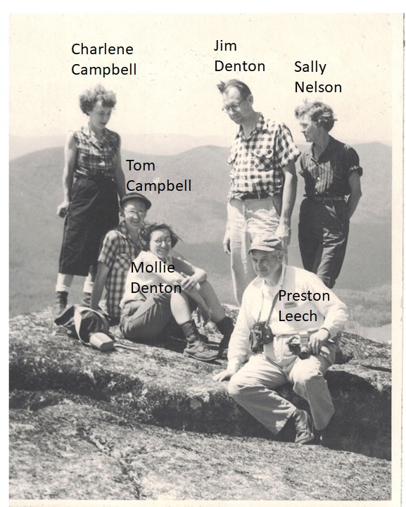
Enter Jim and Mollie Denton as well as Tom and Charlene Campbell. They all joined RATC after the war and revived its leadership role in the southern half of Virginia. Three of the four (Tom Campbell and both Dentons) served as RATC presidents, and they were at the center of both a major trail relocation and the lively social scene of the club.
RATC has been around since 1932, and we are finally pulling together all the records. Acting as the RATC Archivist, I am working to digitize it and write about it. This is the first story.
The Founding
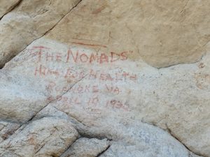
1932 graffiti from Nomad hiking club, whose members helped found the RATC. Photo by Jim Beeson
How do you make a trail building club out of three hiking clubs? Let them build trail where they like to hike. In 1932, Roanoke College had an outings club. So did Hollins College. And hikers from Roanoke and Salem, mostly women, had their own hiking club called The Nomads. On November 13, 1932, members of all three groups went for a walk in Carvins Cove, followed by supper at the home of Donald Gates, an economics professor at Roanoke College. Then they founded the Roanoke Appalachian Trail Club. Their own favorite hiking spots like Tinker Cliffs, McAfee Knob, Carvins Cove, Poor Mountain and Bent Mountain Falls would shape an immediate relocation of the originally planned AT route.
Like other clubs south of Washington, DC, RATC was the brainchild of Myron Avery, the driven and meticulous implementer of Benton McKaye’s visionary Appalachian Trail. Avery became chairman of the Appalachian Trail Conservancy in 1931, when about 1,000 miles of the AT had already been completed. He was also president of the Potomac Appalachian Trail Club and, like Johnny Appleseed, was busy planting new clubs between Georgia and Maine.
The founders of the RATC were hikers. Under Avery’s guidance, some of them would also become expert trail builders. After encountering Avery at an ATC event in the Smoky Mountains, Prof. Gates began corresponding with Avery, and he called a meeting of interested parties at the Roanoke YMCA on October 24, 1932. Next came a two-day meeting with Avery and other PATC members at the Hotel Mons near the Peaks of Otter on October 29-30. It must have been an impressive show. After day hikes to Sharp Top and Flat Top, PATC members showed movies and slides on how to mark and build trail along with scenic views on the completed northern sections. The next day they demonstrated exactly how to construct a trail.
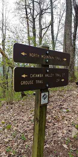
Want more solitude than the Dragon’s Tooth/McAfee Knob/Tinker Cliffs corridor on the Appalachian Trail? Just on the other side of the Catawba Valley, the NORTH MOUNTAIN TRAIL in Jefferson National Forest offers about 12 miles of hiking and camping with far less traffic. The downsides: you may encounter a few mountain bikers, there are no water sources after the first mile, and there are very few views when the leaves are on the trees. But this moderately difficult hike offers great views when the leaves are down – between November and late April or early May. Plan a one-night backpack or allow at least 6 to 7 hours for a day hike. You can position cars at each end (Andy Layne/Tinker Cliffs trailhead and Dragon’s Tooth trailhead.)
The Hiking Upward website offers an excellent map and a detailed description, although the mileages differ slightly from those provided on Forest Service signage. The Forest Service map is geared to people entering from the next valley west but it does include a description of the Catawba Trail that begins near the Andy Layne Trail parking lot. The entire North Mountain hike has excellent signage.
HISTORY. On March 1, 1978, problems with some local landowners forced the relocation of the Appalachian Trail away from McAfee Knob and on to North Mountain on the other side of the Catawba Valley in the Jefferson National Forest. This situation did not last long. On January 24, 1982 Roanoke Appalachian Trail Club volunteers Siegfried Kolmstetter, Charles Parry, Andy Layne, Mac McDaniel and Larry Wood brushed out the first mile of the new trail back to McAfee Knob. Although the AT is no longer there, North Mountain remains an outstanding hike, especially between November and April, when the leaves are down and the views most expansive.
The Roanoke Appalachian Trail Club is looking for new volunteers to protect McAfee Knob and Dragons Tooth as Volunteer Ridgerunners. The final Training Day of 2019 will be Saturday, September 7 from 9 am to 4 pm. Please email Kathryn Herndon-Powell or call her at 540-904-4316 to attend.
Volunteer Ridgerunners engage hikers in friendly conversations about the natural and cultural significance of this area and tips on best practices for enjoying the Trail safely and responsibly. They report on trail conditions and perform light trail maintenance to prevent small problems from getting worse–like dismantling illegal fire rings, packing out trash, and blocking social trails to discourage shortcutting. In 2018, 38 Volunteer Ridgerunners logged 1,125 volunteer hours, spoke with over 18,000 visitors and removed 570 gallons of litter!
If you want to join this lively group of dedicated stewards, you must:
As we get ready to start a new hiking season, both hikers and maintainers might enjoy this piece I wrote in honor of Katahdin guide and caretaker Roy Dudley after finishing a complete section hike of the AT in 2008. Enjoy!
Hikers are from Venus, Maintainers are from Mars ~ Dedicated to the spirit of Roy Dudley, an early Katahdin guide who knew the ways of Pamola
By Diana Christopulos (“DC Turtle,” 2008)
Once upon a time on a long winter night, Pamola, spirit protector of Katahdin, sent for Beaver, his steady minion. “I will put an end to the noise of Hiker and Maintainer always complaining about each other,” said the thunder god, stretching his gigantic wings and flexing his eagle talons. “Their petty insults can be heard from Springer Mountain to my thrice-hidden lair.” Pamola swiveled his stately head and looked off to the south. “Bring them to me! Maybe I will finish them off.”
So Beaver went to the low country and found Hiker, who was enjoying a long zero day, lying on his sofa and eating a Snickers for dessert after a gobbling down Ramen noodles and Slim Jims.
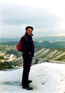
Photo c. 1980; all photos courtesy of Kolmstetter family
The mountains are calling and I must go. In every walk with nature one receives far more than he seeks. The clearest way into the Universe is through a forest wilderness. John Muir
One man who answered the call of our mountains was Dr. Siegfried J. Kolmstetter, who joined the Roanoke Appalachian Trail Club in 1971 and passed away on February 13, 2019.
He and his wife Ursula maintained the McAfee Knob section of the AT for over 25 years.They came to the Roanoke Valley in 1970, where he worked at the Veterans Administration Hospital in Salem for 28 years. The VA hospital recognized Siegfried with its “Hands and Heart” award on February 14, 1992 for his compassionate attitude and unselfish service on the behalf of veterans.
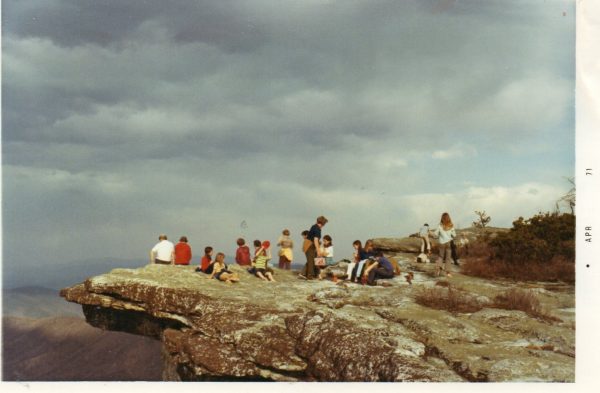
Siegfried leads Brownie troop to McAfee Knob.
On March 16, 1971 – the same year he joined RATC – Siegfried led his first hike to McAfee Knob, guiding a Brownie troop and their leader to the summit.
On March 1, 1978, problems with some local landowners forced the relocation of the AT away from McAfee Knob and on to North Mountain. This situation did not last long, and on January 24, 1982 Siegfried joined Charles Parry, Andy Layne, Mac McDaniel and Larry Wood in brushing out the first mile of the new trail back to McAfee Knob.
(Note: this blog is based substantially on a filing by the Indian Creek Watershed Association/ICWA to the Federal Energy Regulatory Commission/FERC on December 21, 2018 – Accession No. 20181221-5334. As this blog was being posted, several more stories broke regarding likely violations of the Clean Water Act by Mountain Valley Pipeline. In a front-page story on January 23, 2019, the Roanoke Times reported a well-documented request by Roanoke attorneys to the federal Environmental Protection Agency for a criminal investigation of MVP On February 15, 2019 the Roanoke Times confirmed that the there is a federal criminal investigation of MVP underway. And Roberta Kellam, former member of Virginia’s State Water Control Board – charged with enforcing the federal Clean Water Act in the Commonwealth – revealed potential violations by Department of Environmental Quality staff and very questionable behavior by DEQ Director David Paylor. Kellam wrote articles for the Virginia Mercury in December 2018 and January 2019. )
Before approving the Mountain Valley Pipeline (MVP), the Federal Energy Regulatory Commission (FERC) had to show that it would do no substantial environmental harm, supposedly demonstrated in the Final Environmental Impact Statement (FEIS) they issued on June 23, 2017 (Accession No. 20170623-4000). In granting the FEIS, the FERC relied on MVP’s stream scour and erosion analyses and plan containing specific information about pipeline construction at stream crossings along the entire pipeline route.
Yet within months of starting the project, MVP submitted a variance request asking permission to change its plan. In doing so, MVP admitted to the FERC that:
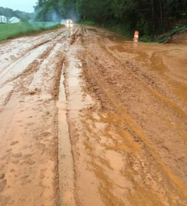
MVP runoff a foot deep on Cahas Mountain Road
“The [MVP plan] was a theoretical desktop analysis and did not take site specific constructability issues (elevations, terrain, and workspace) into account. During its subsequent field reviews, [MVP] determined that execution of the mitigation measures, as written, would pose increased environmental or landslide risks or be unsafe or impractical due to terrain or geology.”
In response, FERC’s own expert consultant stated that MVP should be required to “provide a site-specific scenario… for each location [where MVP proposed to change its original plan].”
So it is clear that the FERC-approved FEIS does not protect the environment. Despite MVP’s confession, Paul Friedman (FERC Project Manager) or someone at a higher level overruled the FERC’s own expert consultant by
Rejecting the expert’s directive that MVP do a site-specific analysis of every water body crossing on the route where MVP proposed to change its original plan.
Allowing MVP to produce revised plans with lower environmental standards (June 2018).
Failing to provide state environmental agencies or the public an opportunity to comment on revised plans.
Approving, without opportunity for public comment, a project-wide variance (MVP-006) on September 26, 2018 that allows MVP to violate Best Management Practices without oversight.
Producing this hasty variance approval at EXACTLY the same time that MVP announced a lengthy delay and major cost increase. MVP and its investors – not clean water, landowner rights and protection of public lands – seemed to be the core FERC audience for this action.
Hiding the relevant correspondence from the public, the courts and both federal and state regulators.
Trying to hide the name of the FERC Project Manager in documents that ICWA acquired through a Freedom of Information Act Request (FOIA).
BY KEEPING CORRESPONDENCE SECRET, FERC DENIED INFORMATION THAT WOULD HAVE INFORMED DECISIONS BY FERC COMMISSIONERS, THE FEDERAL 4TH CIRCUIT COURT OF APPEALS AND THE VIRGINIA STATE WATER CONTROL BOARD, among others. Surely it would have mattered if decision makers had Read more »
Many RATC members know Chris Means as RATC’s Membership Coordinator or as an early co-organizer of the Roanoke Outdoor Adventure Club. But there is a lot more to his story!
As Chris will soon be completing a long and successful career at Elizabeth Arden here in the Roanoke Valley, he’s already been thinking about the future. He still enjoys his work but admits that,
Undoubtedly I had the most fun in my working life at a skate/T-shirt shop in the booming metropolis of Charleston, West Virginia. I of course never made much money at this and eventually moved on, but the atmosphere was fun, my co-workers were incredible, and the job was essentially easy as love mingling with the public. I recall this as the ‘good times’ era in my life. Fast forward 30 years and I find myself entertaining the possibility of doing something similar, but with more thoughtful motivation.
The result is Outdrz.net, Chris’s web-driven effort (also found on Facebook) to combine four goals:
Create and sell great quality products through his online shop.
Get others addicted to the outdoors by any means possible. Vicariously will work, but my aim is to help others find the medicinal value I’ve stumbled onto out there, and if I’m really lucky, ignite a passion for conservation in a few individuals along the way.
Generate enough income to keep this little venture solvent, and who knows, maybe even make a buck or two.
Contribute a percentage of all profit funds to groups currently doing vital work out there conservation groups and other nonprofits.
 Want more solitude than the Dragon’s Tooth/McAfee Knob/Tinker Cliffs corridor on the Appalachian Trail? Just on the other side of the Catawba Valley, the NORTH MOUNTAIN TRAIL in Jefferson National Forest offers about 12 miles of hiking and camping with far less traffic. The downsides: you may encounter a few mountain bikers, there are no water sources after the first mile, and there are very few views when the leaves are on the trees. But this moderately difficult hike offers great views when the leaves are down – between November and late April or early May. Plan a one-night backpack or allow at least 6 to 7 hours for a day hike. You can position cars at each end (
 The Roanoke Appalachian Trail Club is looking for new volunteers to protect McAfee Knob and Dragons Tooth as Volunteer Ridgerunners. The final Training Day of 2019 will be Saturday, September 7 from 9 am to 4 pm. Please
  Once upon a time on a long winter night, Pamola, spirit protector of Katahdin, sent for Beaver, his steady minion. “I will put an end to the noise of Hiker and Maintainer always complaining about each other,” said the thunder god, stretching his gigantic wings and flexing his eagle talons. “Their petty insults can be heard from Springer Mountain to my thrice-hidden lair.” Pamola swiveled his stately head and looked off to the south. “Bring them to me! Maybe I will finish them off.”