Diana Christopulos, RATC Archivist
From the RATC archives ~ 1950s
You will notice that I am referring to the Appalachian Trail as a Project. That is what it is in its present stage. Some of us look upon the Appalachian Trail as a completed trail. In fact it has been measured and blazed over its entire length and guide books printed to cover the entire trail. Such a situation may give the impression that the trail is completed, but it is far from completion.
It is safe to say that the section southwest from Roanoke to Iron Mountain near Damascus is the worst to be found in the whole length of the trail. . . I defy anyone to find anything of interest to the hiker except short stretches such as in Rocky Knob Park and The Pinnacles of Dan, and the Fisher’s Peak Area. These spots stand on their own merits, but they are connected by roads, mostly dirt but some graveled and paved. All wilderness aspect is lost. The very nature of this section detracts from the use of the trail.
In view of this situation, I have attempted to revive interest in a relocation project to get the trail moved to the West. This trail would, as presently planned, leave the present route at Lambert’s Meadow and cross the Catawba Creek Valley to North Mountain. From the Juncture with the North Mountain Trail the proposed route would follow in a general manner a line drawn to Hungry Mother State Park, and there cross over to Iron Mountain and rejoin the present trail.
Report of the President, James W. Denton
1949 Annual Banquet of the Roanoke Appalachian Trail Club
January, 5, 1949
RATC’s founders worked closely with Myron Avery to lay out, mark and build the original Appalachian Trail around and south of Roanoke in the 1930s. Their responsibilities grew in the 1950s, as volunteers led by two extraordinary couples worked with federal agencies and others on a monumental undertaking – relocating about 250 miles of the AT all the way to the West Virginia border. It took almost 40 years to complete the project, but RATC made a great start in the 1950s.
Most of the original route was on private land east of the Blue Ridge, with little more than hand-shake agreements protecting the pathway. Much of it also involved road-walking. As early as 1940, RATC club leaders and US Forest Service officials were advocating a complete relocation of the Appalachian Trail between Roanoke and the Tennessee border.i
World War II put an end to trail building and most trail maintenance. When people like Earl Shaffer, the first documented thru hiker, headed for the AT after the war, it was poorly maintained and poorly marked.
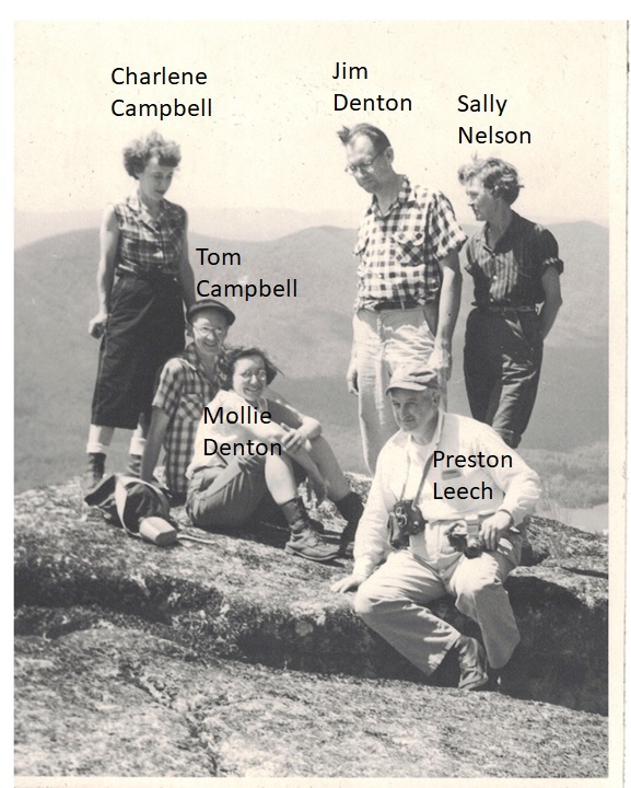
Enter Jim and Mollie Denton as well as Tom and Charlene Campbell. They all joined RATC after the war and revived its leadership role in the southern half of Virginia. Three of the four (Tom Campbell and both Dentons) served as RATC presidents, and they were at the center of both a major trail relocation and the lively social scene of the club.