by Diana Christopulos, RATC Archivist
RATC has been around since 1932, and we are finally pulling together all the records. Acting as the RATC Archivist, I am working to digitize it and write about it. This is the first story.
The Founding
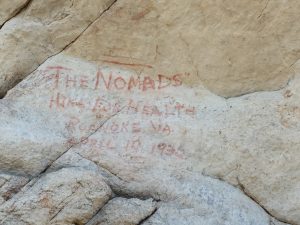
1932 graffiti from Nomad hiking club, whose members helped found the RATC. Photo by Jim Beeson
How do you make a trail building club out of three hiking clubs? Let them build trail where they like to hike. In 1932, Roanoke College had an outings club. So did Hollins College. And hikers from Roanoke and Salem, mostly women, had their own hiking club called The Nomads. On November 13, 1932, members of all three groups went for a walk in Carvins Cove, followed by supper at the home of Donald Gates, an economics professor at Roanoke College. Then they founded the Roanoke Appalachian Trail Club. Their own favorite hiking spots like Tinker Cliffs, McAfee Knob, Carvins Cove, Poor Mountain and Bent Mountain Falls would shape an immediate relocation of the originally planned AT route.
Like other clubs south of Washington, DC, RATC was the brainchild of Myron Avery, the driven and meticulous implementer of Benton McKaye’s visionary Appalachian Trail. Avery became chairman of the Appalachian Trail Conservancy in 1931, when about 1,000 miles of the AT had already been completed. He was also president of the Potomac Appalachian Trail Club and, like Johnny Appleseed, was busy planting new clubs between Georgia and Maine.
The founders of the RATC were hikers. Under Avery’s guidance, some of them would also become expert trail builders. After encountering Avery at an ATC event in the Smoky Mountains, Prof. Gates began corresponding with Avery, and he called a meeting of interested parties at the Roanoke YMCA on October 24, 1932. Next came a two-day meeting with Avery and other PATC members at the Hotel Mons near the Peaks of Otter on October 29-30. It must have been an impressive show. After day hikes to Sharp Top and Flat Top, PATC members showed movies and slides on how to mark and build trail along with scenic views on the completed northern sections. The next day they demonstrated exactly how to construct a trail.
No doubt energized by the training, Gates hosted a meeting and supper on November 13, prefaced by the Carvins Cove hike. Over 20 people showed up, and almost all became founding members of RATC. There were nine men and eight women, not counting Gates’ wife and son. RATC was a very social organization from the beginning, with hiking as the hook for everyone and trail building as the passion of a few. The founding members were:
F.S. Baird
Virginia Caldwell
Mary Lane Charles
Grace Cheveraux, Membership Coordinator
B. Coxwell, Secretary
David Dick, Trail Supervisor
Donald S. Gates, President
Evelyn Gillenwater
John McGinnis, Trail Committee member
Velma Moeschler, Membership Committee member
Selma Mosher
Harold Pearn, Trail Committee member
Elmer Phelps, Trail Committee member
Mae Pond
Grace Pownall, Vice President
Lawrence Pownall, Treasurer
Philip Trout
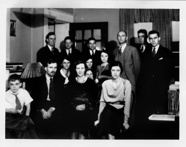
Some of the 20 or so people who attended the founding meeting of RATC, November 13, 1932. RATC Archives
Some are pictured here, at the founding meeting. Donald Gates is in front, second from the left. Grace Cheveraux, in charge of Membership, is fourth from the left. Even though eight of the founding members were women, none were originally named officers. This must have caused further discussion. As reported in a club history written in 1951, at the November 26, 1932 meeting “it was decided that a fifth officer was needed, and Grace Pownall was elected vice-president.”
The club fell into a monthly pattern of hikes followed by supper, with destinations including Tinker Ridge and McAfee Knob (January 23, 1933), Fort Lewis Mountain, Mason’s Knob, and Apple Orchard.
Making Tinker Cliffs and McAfee Knob part of the original Trail
From Avery’s standpoint, the real purpose of the RATC was to build trail. The route laid out by Shirley Cole, extension agent for Floyd County, followed the Blue Ridge for 200 miles. RATC was assigned 55 miles between Black Horse (Tavern) Gap (currently the northern boundary of our territory) and Sweet Annie Hollow, later extended about 15 miles south to include Tuggles Gap, near Rocky Knob. The long section between Tuggles Gap and Pinnacles of Dan, near the North Carolina border, was handled by the Mountain Club of Virginia, which included members from RATC, the Natural Bridge Appalachian Trail Club, Myron Avery and a resident of Pinnacles of Dan.
RATC members did not want to follow the Blue Ridge between Black Horse (Tavern) Gap and Adney, preferring their favorite haunts like McAfee Knob and Tinker Cliffs. A 1945 history of the RATC noted that, “The main problem facing the club in 1933 was the re-routing of the trail from East of Roanoke to Bent Mountain to what club members felt was the more desirable route North and West of the city.” Avery allowed the change, and he personally supervised it. He would “come to the Roanoke area [from Washington, DC] by train on Friday night, often staying at the Meadow View Inn in Daleville where by bus, train, or car club members would meet with him and spend the weekend marking, measuring and mapping the new trail.” The new route descended the Blue Ridge to Cloverdale and climbed Tinker Mountain, running below McAfee Knob on the Carvin’s Cove side, dropping in Mason’s Cove before climbing Ft. Lewis Mountain and crossing US 11 near Dixie Caverns. It then climbed Poor Mountain, passed near Bent Mountain Falls and arrived at Adney Gap. The details of this relocation will be the topic of another blog.
It is clear that hiking and socializing were at the center of the original RATC, with trail building spurred on by Avery. Long and short hikes were scheduled each month and first shared by post cards, later by the Bulletin, a monthly mimeographed production that included information about ATC happenings. Short hikes were the most popular, with many originating at Roanoke’s downtown YMCA, with hikers reaching the trailhead by train or bus. Very few people owned cars at this time. Members went on excursions to Cave Mountain Lake, a YMCA camp, Arcadia and Virginia Beach. They rented Wild Air, the specious old building near McAfee Knob that now exists only as a fire place with the name engraved. They had an annual photo contest, though the results have not survived.
Myron Avery managed to harness the energy of a hiking social club to get 70 miles of the new AT blazed, and RATC members played key roles in completing the entire section in southern Virginia. By 1933, Trail Supervisor David Dick created a trail map for the southern half of Virginia that was sold by Avery’s PATC. Our archives include several hard copies! But that is a story for another day.
References
1933 report of Roanoke Appalachian Trail Club. Transcribed by D. Christopulos, March 20, 2020. Unsigned. RATC archives, 1930s.
Powell, L. H. (1951, January 24). Roanoke Appalachian Trail Club. Transcribed and annotated by D. Christopulos, March 20, 2020.
RATC History, 1932-1945. Unsigned. RATC archives, 1940s.