 The rules about vehicles on the Appalachian Trail are very clear. You can’t ride a bicycle on it. Nor
can you use a motorized vehicle.
36 CFR 7.100 – Appalachian National Scenic Trail. (a)What activities are prohibited? (1) The use of bicycles, motorcycles or other motor vehicles is prohibited.
The US Forest Service knows this and says so on the website for the George Washington & Jefferson National Forest:
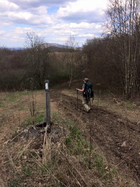
The A.T. is marked with white vertical paint blazes, two-inch by six-inch. It is a foot trail – travel by horse, bicycle, or motorized vehicles is not allowed.
And according to a more specific order for this national forest, “Vehicles, horses, pack animals’ and bicycles” are prohibited on the A.T. unless there is “a permit specifically authorizing the otherwise prohibited act or omission.” We have seen no such permit, nor does any closure order we have seen state that Forest Service personnel are authorized to use motorized vehicles on the A.T.
“Violations of these prohibitions are punishable by a fine of not more than $5,000 for an individual or $10,000 for an organization, or imprisonment for not more than 6 months, or both. (16 U.S.C. 551, 18 U.S.C 3559 and 3571).”
According to the Roanoke Times, though, security forces for both Mountain Valley Pipeline and the US Forest Service road ATVs up and down the AT for 19 days with Forest Service permission, avoiding a walk of less than 1/4 mile to and from a round-the-clock camp where they were denying access to food and water for a protesting tree sitter.
Kris Schneider (a 2002 AT thru hiker who moved from Ohio to the New River Valley after seeing the area) discovered the damage and reported that the AT had become a muddy road six to eight feet wide. Andrew Downs of the Appalachian Trail Conservancy followed up with the Federal Energy Regulatory Commission.
One day after the original story appeared in the Roanoke Times, a law enforcement agent for the US Forest Service issued an apology, claiming that they were using the ATVs “to conduct welfare checks” on protesters. It seems much more likely that these were shift changes for the armed security forces. At times they traveled two abreast, buzzing past a hiker on the AT:
So we have some questions:
- Who authorized Mountain Valley Pipeline to drive ATVs on the Appalachian Trail for 19 days?
- Did US Forest Service Personnel also participate in driving ATVs on the Appalachian Trail?
- Who was in authority on top of Peters Mountain?
- Citizens who did this would be fined – each person for each incident. What fines will be levied?
- What actions will be taken with regard for officials who allowed this to happen?
For your information, below are two maps showing the location of single tree sitter on the West Virginia side of Peters Mountain (where the ATVs were used) and the monopole sitter on the Virginia side. The first map is a larger view showing both sits; the second is close up on top of Peters Mountain, where the ATVs were used. The distance traveled by the ATVs is only an estimate based on knowledge of the trail on top.
MAPS – Google Earth screen shots. The first one shows the whole access road (7 miles); the second is a close up on top of Peters Mountain
MAP 1 – both protester locations visible
RED = pipeline route
ORANGE = APPALACHIAN TRAIL
PURPLE = future pipeline access road; current AT maintainer road (Pocahontas Trail, then Mystery Ridge Road)
GREEN = western boundary of Peters Mountain Wilderness
WHITE = Va/WV state line (the AT pretty much follows it)
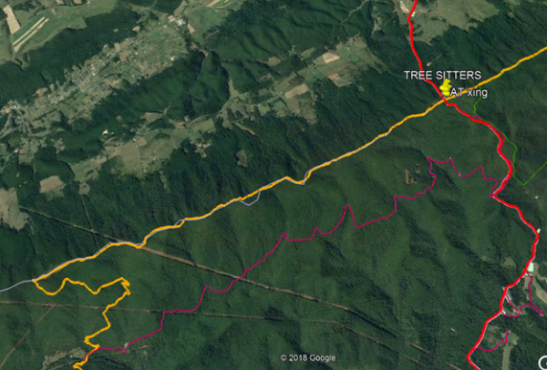
At bottom left, you can see where Pocahontas Road overlaps the AT – near monopod. It is about 7 miles from Clendinnin Road intersection to crest of Peter’s Mountain and AT.
At top right, it is about 1/4 mile from where Mystery Ridge Road comes out at the AT to the tree sitters (yellow pin) and the 24 x 7 camp made by USFS et al. They are about 300 feet below the AT on the West Virginia side, still in Jefferson National Forest.
MAP 2 – close up on top of Peters Mountain, where ATVs were
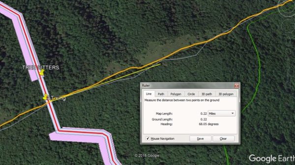
The big opening on the right in the photo below is Symms Gap Meadow.
We used the “ruler” function in Google maps (yellow line below orange AT line) to determine the approximate distance between emergence of Mystery Ridge Road at Symms Gap and the tree sitter and MVP/FS camp. About 1/4/mile. We ALWAYS walk it when we go up there, as do FS staff and everyone else.