Red line = proposed route of Mountain Valley Pipeline
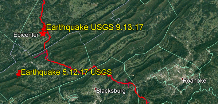
On September 13, 2017, Monroe County, West Virginia experienced the largest earthquake in decades, with the epicenter 1.5 mile from the proposed Mountain Valley Pipeline route.
The Roanoke Times reported that more than 200 calls came into the Giles County Sheriff’s Office dispatch in the half hour after the quake. Within a day, over 500 citizens notified the USGS that they had felt the earthquake.
The Virginia Tech Seismological Observatory rated it a magnitude 3.7 earthquake, while the US Geological Survey pegged it at 3.2 (they use slightly different measurement strategies).
Wednesday’s earthquake is the second one that was felt within 4 months in the GCSZ, with another on May 12, 2017 near Narrows, Virginia (magnitude 2.8).
WHY PIPELINES AND EARTHQUAKES DON’T MIX
Well, these weren’t huge earthquakes, so what’s the problem? Very simply, Mountain Valley Pipeline has chosen to place a very large (42”), explosive pipeline under enormous pressure (1,440 pounds of pressure per square inch) on a very dangerous route. Threats to communities near and downstream from the pipeline include:
- Increased leakage of hazardous materials such as methane, particulate matter, volatile organic compounds, and radon from the pipeline into drinking water wells and public water supplies.
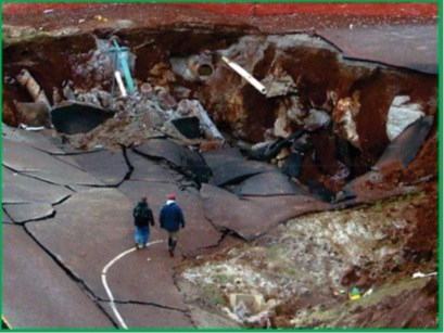
- Increased risk of pipeline failure, producing catastrophic damage within as much as 7,700 feet on each side of the pipeline. WANT TO SEE WHAT A MUCH SMALLER 20″ PIPELINE LOOKED LIKE WHEN IT EXPLODED AND MELTED PART OF INTERSTATE 77? THIS IS THE SISSONVILLE, WV PIPELINE IN DECEMBER 2012.
- Increased risk of major wildfires due to potential explosions on a route that is very heavily forested.
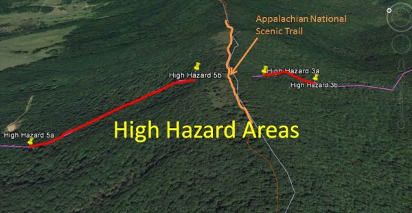 WORST POSSIBLE LOCATION: PROPOSED CROSSING OF APPALACHIAN TRAIL
If you were going to combine all possible risk factors for the Mountain Valley Pipeline in one location, the proposed crossing of the Appalachian Trail could be that spot. The September 13, 2017 earthquake was only 5-6 miles from the proposed crossing of the AT on top of Peters Mountain, immediately next to the Peters Mountain Wilderness on the Virginia/West Virginia border.
The US Forest Service identified numerous High Hazard Areas in Jefferson National Forest associated with construction of Mountain Valley Pipeline. Two of the High Hazard areas are immediately adjacent to the Appalachian Trail (300 feet away on each side) on both sides of Peters Mountain (see visual above).
Risk factors include:
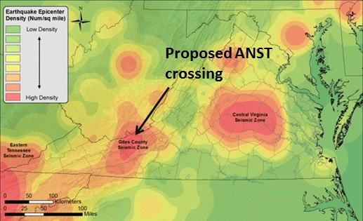
- Location in the middle of the very active Giles County Seismic Zone.
- Location between what the US Forest Service has identified as two High Hazard zones that combine very steep slopes, with landslide prone soils, and high exposure to seismic action.
- All of the dangers are increased if the soil is wet.
- The bottom of the slope on the West Virginia side is full of karst, as noted by Dr. Kastning, so that a failure would impact a wide area.
At a live meeting in Salem, Virginia on June 15, 2017, I asked an MVP construction supervisor to cite one example of a pipeline this size that was successfully constructed in an environment of steep slopes, landslide prone soils, karst and an active earthquake zone. His answer was: “FLORIDA.” Obviously, Florida has karst. But none of the other hazards are present.
Mountain Valley Pipeline seems largely unaware of or unconcerned about the risks. They seem to believe that stating there is no problem in fact means there is no problem. Since the company itself is not being required to post any bond nor pay the cost of any damage that is done to the surrounding area, it is not surprising. All of the costs would be borne by those who are most directly impacted and who have the least resources to spare.
WHY MOUNTAIN VALLEY PIPELINE IS ESPECIALLY RISKY
Unlike the 20” pipelines currently supplying the much of the East, Mountain Valley would not follow existing utility and transportation routes through relatively flatter ground. Instead, it would combine the following risks:
- It would run right through the middle of the Giles County Seismic Zone (GCSZ), site of the huge 5.8 magnitude earthquake in 1897 that was felt in 12 states, including Ohio, Georgia and Indiana. It actually cracked the rocks on “Angel’s Rest” above Pearisburg (now on the Appalachian Trail). The shocks of earthquakes are often amplified on ridges when they cross under mountains.
- STEEP SLOPES. In the area of the recent earthquake, average maximum vertical slopes of the proposed pipeline route are 40 to 60%, creating a high risk of slippage or failure.
- POOR SOILS. The slopes often have landslide-prone soils, exposing the pipe to greater failure risks, especially when it rains.
- KARST. In valleys, the route is often in karst, limestone/dolomite formations filled with unseen sinkholes, creeks and rivers. Large pipelines that fail in karst can create a 3-mile-wide disaster zone.
- HEAVY RAINFALL. Mountain Valley Pipeline admits that wet slopes have a very significantly increased risk of slippage. Extreme rain events have been common in the region where Mountain Valley Pipeline proposes this project, and climate change will mean stronger events in the future:
- Greenbrier County, West Virginia (on the proposed route) received 10 inches of rain in 12 hours in June 2013 – considered to be a 1,000-yr flood
- Virginia suffered 3 hurricanes in a row in September 2004, causing 50 to 100-year floods, depending on location
- Roanoke endured the largest flood in its history in November 1985
- The City of Roanoke had four 25-year floods in just over a year.
Yet Mountain Valley Pipeline has proposed to use a 2” rainfall as the standard for heavy precipitation.
Each of these risks is significant by itself, but they also amplify each other. An earthquake shakes steep, landslide-prone soils – encouraging leakage, slippage and failure. In his widely lauded summary of the geologic risks associated with Mountain Valley Pipeline, karst expert Dr. Ernst Kastning repeatedly noted that the earthquake activity (seismicity) of the region was most dangerous because it was combined with other very serious risk factors. Writing specifically about Monroe County, West Virginia where the September 13, 2017 earthquake occurred (p.32), Dr. Kastning observed that:
The preferred route of MVP passes through the center of the Giles County Seismic Zone . . . Should a potential magnitude 4 to 6 earthquake occur once the pipeline is operational, there may well be a triggering of landslides on unstable or metastable slopes that could potentially disrupt the pipeline and cause significant collateral damage. Perhaps the pipeline itself may be directly broken by ground motion during an earthquake. It is clear that steep mountain slopes in the area of Monroe, Giles, Montgomery, Craig, and Roanoke counties are subject to mass movement including large landslides. Seismicity and severe runoff from storms have triggered these events in the past and can easily do so in the future. Earthquakes do not necessarily have to be large to do damage to the pipeline. Small events can easily trigger mass movement on metastable slopes. The Mountain Valley Pipeline would be most subject to these hazards in the many areas having steep slopes.
In karst, found in the valleys along much of the proposed route, an earthquake can encourage sinkhole-induced pipeline failure. A sinkhole failure occurred in Adair County, Kentucky on February 13, 2014, tossing 80 feet of carbon steel pipe in large pieces up to 380 feet away even though it had been buried 4.7 to 8.5 feet deep. The rupture created a crater approximately 105 feet long, 44 feet wide, and 25 feet deep.
Desktop calculations based on experience with smaller pipelines suggests that Mountain Valley Pipeline would have a blast zone (incineration) of approximately 1,100 feet on each side and an evacuation zone (risk of serious injury) of at least 3,600 feet on each side. A filing to the Federal Energy Regulatory Commission on behalf of Roanoke and Giles counties includes a study by Paul Rubin concluding a safe evacuation distance from such a pipeline in karst would be a minimum of 7,544 feet on each side.
WHY ARE NEW NATURAL GAS PIPELINES SO UNSAFE?
Pipelines built since 2010 have a much higher failure rate than at any time since before World War II. Experts suggest that this poor performance is due to hasty construction in unsatisfactory terrain, a description that fits Mountain Valley Pipeline.
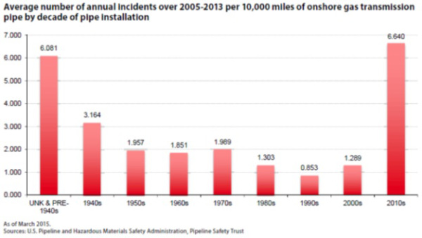
The graph above goes through 2015. The data have not improved since then. According to data collected by the US DOT Pipeline and Hazardous Material Safety Administration (PHMSA) for gas pipelines:
- From 1997 to 2016, there were 11,462 significant incidents costing $7,058,024,527.13 These incidents killed 324 people and injured another 1,331.
- In just the first five months of 2017, there were 201 incidents costing $44,031,235. The damage caused by each incident is significantly higher than in the past.
MOUNTAIN VALLEY PIPELINE WOULD USE INADQUATE SAFETY PRACTICES
At a live meeting in Salem, Virginia on June 15, 2017, I asked an MVP construction supervisor to cite one example of a pipeline this size that was successfully constructed in an environment of steep slopes, landslide prone soils, karst and an active earthquake zone. His answer was: “Florida.” Obviously, Florida has karst. But none of the other hazards are present.
Mountain Valley Pipeline is using construction practices that were not designed to withstand seismic zones, karst or long, steep slopes in this region. They reference a document called “Mitigation of Land Movement in Steep and Rugged Terrain for Pipeline Projects” by the Interstate Natural Gas Association of America (INGAA) published in May 2016 as the basis for construction of the project. However:
- This document is designed for the low plateau of West Virginia, not to the high plateau where this project is proposed.
- It does not even contain the word “seismic” in it, so it is clearly not addressing earthquake zones.
- Nor does it contain the word “karst,” even though the lowlands of the project are full of karst.
Let’s conclude with a few more comments from Prof. Kastning’s work, “An Expert Report on Geologic Hazards in the Karst Regions of Virginia; Investigations and Analysis Concerning the Proposed Mountain Valley Gas Pipeline”
With or without a significant seismic event, slope failure is in itself a significant continuing concern. In commenting to FERC on March 30, 2015, Dr. Robert Tracy (Professor of Geosciences at Virginia Tech) states: “Even holding constant the seismic hazards, along the MVP route most subject to seismic activity, there is a very high probably of differential slope failure, with slide masses moving at differential rates with abrupt boundaries (effectively soil faults) separating masses.”
Even though a very-high-magnitude earthquake (Richter magnitude 5.0 or greater) has not occurred in the GCSZ since 1897, the more time that elapses, the more likely it is that such event may occur.
. . . continuing seismic activity in the GCSZ (a high frequency of magnitude 2.5 or larger earthquakes), produces a major risk when compounded with the already co-existing problems of karst, slope, and soil hazards at sensitive locations along the proposed pipeline route. This poses severe engineering challenges in constructing the pipeline, and calls into question whether the pipeline should be built at all.
Compounding of hazards along the preferred route alone suggests that avoidance of the region altogether is in the best interest of MVP and FERC, and certainly to the overwhelming majority of residents of Giles and adjacent counties.