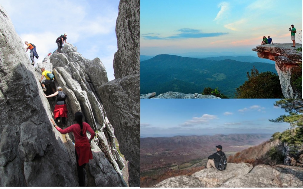
Virginia’s Triple Crown – Dragon’s Tooth, McAfee Knob and Tinker Cliffs – is part of the Appalachian Trail between VA 620 (Trout Creek) and VA 652. The Roanoke Appalachian Trail Club maintains this section along with about 100 miles of the AT south and north of it. This page will help answer questions about McAfee Knob and Virginia’s Triple Crown. For the latest news and alerts on Virginia’s Triple Crown, or to message us with specific questions, please check our Facebook page.
- IS IT CROWDED?
- WHAT SHOULD I BRING?
- WHERE CAN I PARK?
- SHOW ME A MAP!
- HOW CAN I HIKE TO McAFEE KNOB?
- WHERE CAN I CAMP?
- WHAT SPECIAL RULES APPLY?
- WHERE CAN I FIND PLACES TO STAY IN THE AREA?
- I WANT A T-SHIRT!
IS IT CROWDED?
Plan your Triple Crown hike during the week, if at all possible. Weekend days are generally crowded especially in spring (March-May) and fall (September-November). McAfee Knob receives about 60,000 visitors every year, so it is really important to Leave No Trace.
WHAT SHOULD I BRING?
The Subaru National Leave No Trace trainers conducted training and awareness programs near McAfee Knob in 2015 and 2017. After their most recent visit, they prepared this short video with tips for people who want to enjoy McAfee Knob while treading lightly. At the very least, wear good walking/running shoes or boots, bring 1-2 liters of water per person (plus some for your dog), a snack and a real flashlight – not your cell phone! Better yet, bring the 10 Essentials in the video.
WHERE CAN I PARK?
Triple Crown trailheads. These are heavy use areas and parking lots may fill up early, especially on weekends and holidays. Hike on a weekday if possible. The McAfee Knob Trailhead Shuttle Service, a partnership between Roanoke County and Ride Source, operates Fridays, Saturdays, and Sundays during spring, summer, and autumn. Consider using a shuttle driver if doing a long distance hike.
From south to north, potential parking areas are:
TROUT CREEK PARKING AREA (Va 620). Overnight parking allowed.(From Roanoke) Follow directions below to Dragon’s Tooth parking area. Proceed another 4.1 miles on Va 311 and turn left on Va 621. Drive 2.8 miles on Va 621 to Va 620. Turn left on Va 620 and drive 1.1 miles to Trout Creek parking area. Click here for Google Maps directions to the Trout Creek parking area.
DRAGON’S TOOTH PARKING (US Forest Service lot). Overnight parking is NOT allowed. (From Roanoke) Take I-81 south to exit 141. Go left on Virginia VA 419, Electric Road. Go 0.4 miles to VA 311. Take right. In 4.6 miles, pass McAfee Knob trailhead parking lot on left at top of Catawba Mountain. To reach Dragon’s Tooth parking lot, continue on VA 311 for another 3.5 miles to US Forest Service Dragon’s Tooth parking lot on left, just after the intersection of VA 311 and VA 624/Newport Road (gas station and convenience store on the left). If using Google maps, always use “Dragon’s Tooth parking area” as the search term; other terms may take you to completely different locations. Click here for Google map directions to Dragon’s Tooth parking area.
McAFEE KNOB PARKING – VA 311 – 4440 Catawba Valley Road (National Park Service lot). The new pedestrian bridge and redesigned parking lot are now open. DO NOT PARK ALONG 311. Parking is not allowed on VA 311 – illegally parked cars may be ticketed and towed. LIMITED parking is available along Old Catawba Road (Rt. 864) – follow the signage for where parking is allowed.
Consider these parking alternatives:
- Use the seasonally available McAfee Knob Trailhead Shuttle Service if you are planning your hike on a Friday, Saturday, or Sunday.
- Go downhill less than 0.25 mile towards I-81 and turn right on Virginia Route 864. Park as far off the road as possible and do not park on sharp turns; this road is used by emergency vehicles. Be aware that improperly parked vehicles have been ticketed and towed on this road.
- Park at one of the two daytime lots on VA 779 – directions are below. Details about this section and the connecting hikes are here.
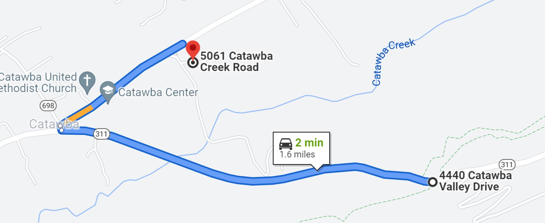
CATAWBA SUSTAINABILITY CENTER (CSC) – 5061 Catawba Creek Road (VA 779) is a two-minute drive from the McAfee Knob parking via VA 311. No overnight parking. At least 25 parking spaces available.
- Drive 1.1 mile west (left out of McAfee parking) on VA 311 to the bottom of the hill.
- Turn right on VA 779/VA-698 N and then immediate sharp right on VA 779. You will pass the post office and the Catawba Community Center and see two large old silos ahead on the right – that is the CSC.
- At 0.4 miles after leaving VA 311, just after a mailbox, turn right into CSC . There are marked parking spaces for 25 cars, including 2 handicapped spaces. There is a wheelchair-accessible port-a-pot. The trail begins at the gate across the road. Follow the orange blazes!
- Round trip to McAfee Knob: a little over 10 mi.
CATAWBA COMMUNITY CENTER – 4965 Catawba Creek Road (SR 779). Same directions as above – you actually see it first. No overnight parking. About 15 parking spaces available.
- Round trip to McAfee Knob: about 10.5 mi.
- There may be a Farmer’s Market or other community activity going on.
ANDY LAYNE TRAIL (Tinker Cliffs). Overnight parking allowed. (From the north) From I-81, exit 150B, go north on US 220 for 1.75 miles. Turn left on Catawba Road (VA 779). Go 7.6 miles. The gravel parking lot for trail head is on left. This blue-blazed trail to the AT provides access to Tinker Cliffs. (From the south) From I-81, take Exit 140 west (left turn) on VA 311. At first stop light, turn left to stay on VA 311 for 6.7 miles (passing McAfee Knob parking at top of mountain before descending into Catawba). At bottom of mountain, turn right onto Va 779/698 North. In 75 feet, turn right onto Va 779 (road splits) and go 2.3 miles. Turn left onto Va 600 and go 1.2 miles; continue onto Little Catawba Creek road for 4.2 miles. Slight left onto Va 779 – then turn right into Andy Layne parking lot at right in 0.1 mile. Note that Google maps does not provide a good map to this location. However, you can get directions from Google based on the GPS location of the parking area.
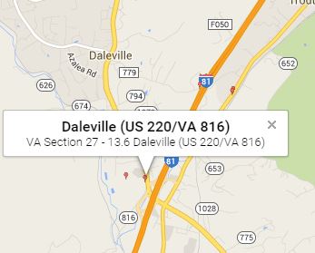
DALEVILLE PARK AND RIDE LOT AT I-81 EXIT 150. Overnight parking allowed. From I-81, take US 220 about 0.5 miles northwest of Exit 150 and turn left into Park and Ride, just before gas station (see map of location). This parking can be used for a section hike that includes Dragon’s Tooth, McAfee Knob and Tinker Cliffs via the Appalachian Trail. Click here for Google Maps directions to the Daleville Park and Ride area parking.
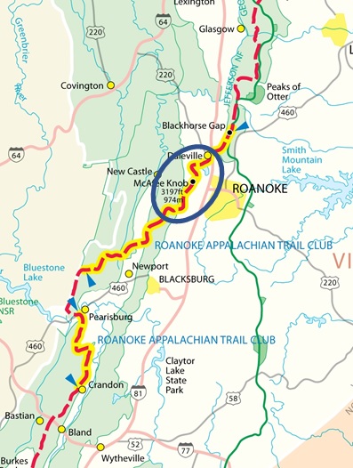
SHOW ME A MAP!
Looking for maps of Virginia’s Triple Crown? This link has an overview map of the entire Triple Crown and this link is a map of the day hike to McAfee Knob. For a detailed map, you can go to an outdoor store or purchase Map of Catawba Triple Crown online from tanZ Navigation. The maps are waterproof and contain the entire Triple Crown section. A good map of the Andy Layne Trail and Tinker Cliffs is here.
HOW CAN I HIKE TO McAFEE KNOB?
The hike from the VA 311 parking lot to McAfee Knob is just under 8 miles round-trip, with a 1,400 foot gain in altitude, most of it in the final 1.5 miles. Most people take 4 to 6 hours to complete the hike. Be sure wear good walking shoes and take water, a flashlight (cell phones don’t count as flashlights), a snack, a map, a compass and extra clothing.
PLEASE NOTE: This hike and the hike to Tinker Cliffs are on National Park Service lands. All dogs must be on a leash for everyone’s safety.
Here are several ways to hike from the VA 311 parking lot:
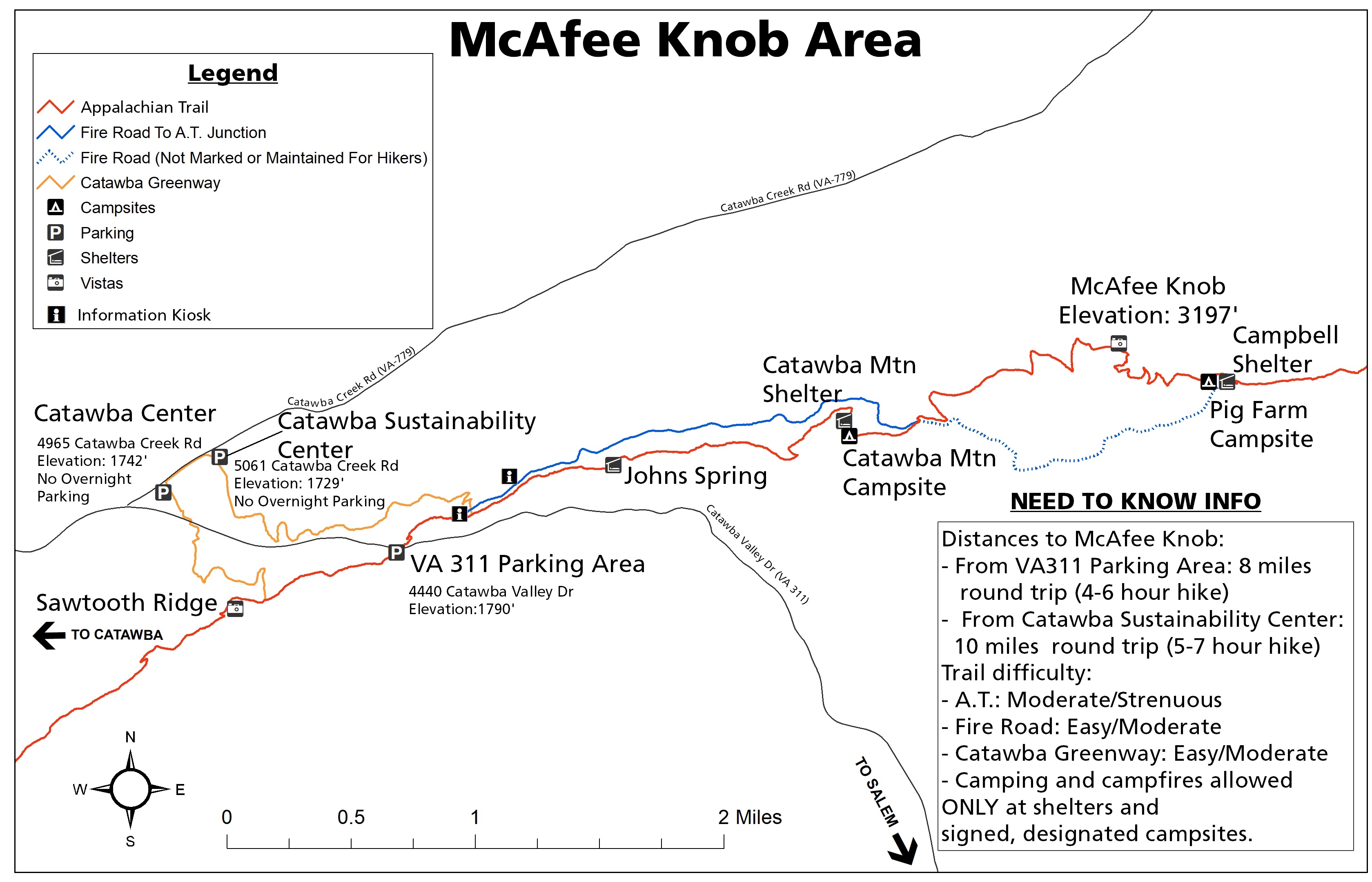
- Via the AT and the fire road: From the parking lot (P) begin by carefully crossing Va 311 to the white-blazed Appalachian Trail (brown line). Climb the hill and steps on the AT. In about 0.5 mile, you will reach a kiosk (“i” on the map). Go left towards the fire road and then right on the fire road (blue line). Walk about 2 miles on the fire road to its second junction with the AT (end of solid blue line on map) – many people who take the fire road miss this turn! Turn left up the stone steps to take the AT (brown line) to McAfee Knob, about 1.5 miles. At the top of your climb, you will see a sign pointing left towards the View at McAfee Knob. Allow 4 to 6 hours.
- Via the AT: From the parking lot (P) begin by carefully crossing VA 311 to the white-blazed Appalachian Trail (brown line). Climb the hill and steps on the AT. In about 0.5 mile, you will reach a kiosk (“i” on the map). Go right to stay on the AT (brown line). The AT will again cross the fire road in about 2.5 miles (intersection of solid blue and brown lines beyond Catawba Shelter and Catawba Campsite). Stay on the AT by climbing the rock steps on the far side of the fire road and climbing about 1.5 miles to McAfee Knob. At the top of your climb, you will see a sign pointing left towards the View at McAfee Knob. Allow 4 to 6 hours.
- Returning via the fire road: Heading back from McAfee Knob towards the 311 parking lot, take the AT (brown line) for about 1.5 miles to its intersection with the fire road (blue line). Turn right on the fire road (blue line) and walk about 2 miles to its junction with a marked spur trail back to the AT. Stay left at the junction and walk up to the kiosk (“i” on the map), which is on the AT (brown line). Turn right on the AT to return to the 311 parking lot in about 0.5 mile. Some folks get a little confused on this section!
- Via the new Catawba Greenway: Park at either the Catawba Sustainability Center (CSC) or the Catawba Community Center and access the AT fire road via the new Catawba Greenway. It is 1.7 mile from CSC parking to the AT fire road and about 3.5 miles further to McAfee Knob. Total round trip: about 10.4 miles. Allow 5 to 7 hours. See more details about this option here.
- Alternate walk: Sawtooth Ridge. Prefer a shorter walk? It is only about a mile to a nice overlook in the opposite direction from McAfee Knob. From the parking lot, walk away from Va 311 on the Appalachian Trail (brown line) to the overlook on the left. You are looking into Mason’s Cove. Allow one hour.
WHERE CAN I CAMP?
McAfee Knob and the Triple Crown are part of a national park unit – the Appalachian National Scenic Trail – that is managed collaboratively by the National Park Service, the US Forest Service, the Appalachian Trail Conservancy and the Roanoke Appalachian Trail Club. Usage of this section of the AT has increased dramatically in the past 6 years. If you plan to take on this challenge, please respect the resource and the beings that inhabit it by practicing Leave No Trace principles. The volunteers of RATC hope you enjoy and treasure the trail!
Thoughtful dispersed camping is allowed in Jefferson National Forest (JNF). A notable exception is the area along the Dragons Tooth Trail and the Boy Scout Trail, near the Dragons Tooth parking lot. This is a Special Biological Area where camping is prohibited to protect rare species. Dispersed camping is allowed along the Appalachian Trail in the National Forest (south of SR 624). There are no natural water sources along the A.T. in the Dragons Tooth area, so bring all your water if planning to camp in that area.
PLEASE NOTE: When you leave JNF north of Dragon’s Tooth at SR 624, you enter National Park Service land, and camping is restricted to the 7 sites seen on the map below – Johns Spring Shelter, Catawba Shelter and Campsites, Pig Farm, Campbell Shelter, and Lambert’s Meadow Shelter and Campsites. NO CAMPING at McAfee Knob or Tinker Cliffs. Click here to download a larger version of the overview map shown below.

WHAT SPECIAL RULES APPLY?
As shown on the map above, please be aware of these federal rules for the heavily used Triple Crown section between Virginia 624/Newport Road and US 220/Daleville:
- NO camping outside of 7 designated areas north of SR 624/Newport Rd. The only legal campsites are (refer to map above):
- Johns Spring Shelter,
- Catawba Shelter and campsites
- Pig Farm Campsite
- Campbell Shelter
- Lambert’s Meadow Shelter and campsites
- NO campfires outside of metal fire rings in the designated camping areas. Please exercise caution – a small fire on this section took 4 days to put out in November 2016.
- No camping or campfires on McAfee Knob or Tinker Cliffs
- No camping or campfires in Carvin’s Cove, the City of Roanoke conservation easement adjacent to the AT in the Tinker Cliffs/Lambert’s Meadow area
- Maximum group size for day hikes is 25
- Maximum group size for backpacking/camping: 10
- No alcohol
- Dogs must be kept on leash at all times – this is National Park Service land with special rules
- No e-Collars
- Pets must be restrained on a leash that does not exceed six feet in length.
- Pet excrement shall be disposed of only at sanitary facilities within the park or must be buried six (6) to eight (8) inches deep at least 200 feet from any trails, overnight sites or water sources.
PLEASE PRACTICE NO TRACE AND CARRY EVERYTHING OUT!
NATIONAL PARK SERVICE AND USE OF DRONES:The NPS prohibits the use of drones on the AT section from VA 624 (just trail-north of Dragon’s Tooth) to VA 652 (trail-north of Troutville). This is includes both the McAfee Knob and Tinker Cliffs sections.
WHERE CAN I FIND PLACES TO STAY IN THE AREA?
Coming from out of town to day hike or stay in town before or after your hike? Salem is the closest town to McAfee Knob, accessed via I-81 exits 137, 140 and 141. It has many restaurants, a brew pub and a farmer’s market. Distance to Triple Crown trailheads from downtown: 9 miles to McAfee Knob, 13 miles to Dragon’s Tooth, 18 miles to Tinker Cliffs/Andy Layne Trail. Motels are available at I-81 exits 141 and 137. See a map of motels and pricing here.
I WANT A T-SHIRT!
Want to show your love of McAfee Knob/Virginia’s Triple Crown and support the Roanoke Appalachian Trail Club? Proceeds support the mission of the Roanoke Appalachian Trail Club (RATC) to maintain 120+ miles of trails, 16 shelters and privies, and 53 bridges on the AT from Lickskillet Hollow in Giles County to Black Horse Gap in Botetourt County, including Virginia’s Triple Crown: Dragon’s Tooth, McAfee Knob and Tinker Cliffs.


McAfee Knob shirts are available in various styles and sizes from The RATC Store.