Small area, big problems: Mountain Valley Pipeline and Jefferson National Forest
[summary of US Forest Service’s March 9, 2016 comments on developer’s final Resource Reports in October 2015]
 The proposed Mountain Valley Pipeline would be over 300 miles long, including about 5 miles in the Jefferson National Forest (JNF), where it would cross the Appalachian National Scenic Trail (AT) on Peters Mountain (photo at left) and come close to the AT on Sinking Creek Mountain, Craig Creek Valley, and Brush Mountain. In March 2016 the US Forest Service delivered 32 pages of comments on the developer’s lengthy final Resource Reports. A Pittsburgh-based partnership led by the EQT Corporation proposes to cross mountain ridges, steep slopes, streams, rivers and valleys with a huge 42-inch pipeline full of fracked natural gas under high pressure. The gas is destined for overseas markets and other places east of Virginia’s Blue Ridge.
The Forest Service comments are pretty easy to summarize. If a student received these comments on a class project, the grade would be “Incomplete” or perhaps a generous D minus. A job applicant who received the comments on a work sample would not get an interview.
The developer’s latest report was clearly crafted to mislead reviewers by callously downplaying the project’s visual impacts, glossing over potentially catastrophic geologic issues, denying water quality and other environmental impacts, and simply ignoring clear requirements for crossing public lands with a private scheme. As Forest Service staff noted:
- The entire section on Environmental Consequences on Jefferson National Forest Lands is “woefully inadequate” since it does not describe direct, indirect or cumulative effects of the pipeline.
- “Significant materials, including viewshed analysis and maps, have been left out of this comprehensive package of ‘final’ Resource Reports. The proponent should re-review this entire package to ensure completeness.”
- The product is so vague and inconsistent that it “leads reviewers to question the level of critical analysis which was dedicated to developing these ‘final’ products.”
Here is a quick look at problems with the pipeline proposal in the JNF.
Misleading portrayals of visual impacts. The developer says that a 42-inch pipeline and its treeless 125-foot right-of-way going up and down mountains while making 29 water crossings will “provide the ordinary/common or high scenic quality” already present in JNF because “The landscape has the ability to absorb the visual change.”
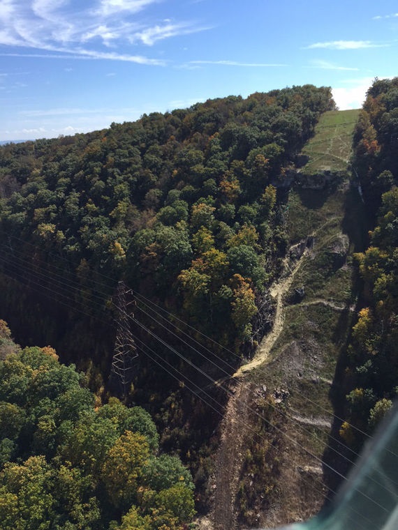
Here is a good test of that assertion: the photo on the left shows the new 12-inch Celanese pipeline crossing Peters Mountain. Anyone who drives US 460 west between Pearisburg and Narrows can see that the landscape did not “absorb the visual change” of this small pipeline and its obvious erosion on a steep slope.
Imagine a pipeline almost four times as large crossing the AT on the same mountain. As noted by the Forest Service, the developer has never provided a map that shows exactly where they propose to cross the AT. Instead, the developer has delivered vague, imprecise maps and a comment that they might shift the route up to 1,300 feet in any direction, calling this a “minor route modification.” In fact, such a change could move the pipeline into the Peters Mountain Wilderness or onto AT property that is administratively controlled by the National Park Service, which would require approval by an act of the US Congress.
What would such a pipeline look like from the AT and other viewing points such as highways used by tourists and residents in the area? The developer says it would look like the photo below, a picture that the Forest Service characterizes as “not informative and. . . deficient for use in determining potential impacts to scenery as viewed from the [AT].”
 The photo is a cynical trick. As proposed, the pipeline would bore underneath the AT only 100 feet from the trail on each side. However, it would still travel up and down the slopes of three mountains in JNF – Peters Mountain, Sinking Creek Mountain and Brush Mountain. Instead of selecting points on the AT and other public trails, roads or highways where the pipeline’s route would be clearly visible (and as required by the Forest Service), the developer shows a tiny slice of the actual crossing spot. To further distort the impact, the photo is taken during the warmer months, so that leaves obscure the view. The standard Forest Service protocol requires views with no leaves.
 Earthquakes, landslides and other geologic issues ignored. The longest part of the Forest Service’s 32-page comments addresses geology. The developer claimed that, “Operational impacts on geologic resources are expected to be minimal.” The Forest Service judged this statement to be “a grossly deficient assessment of the various geologic hazards that may affect, or be affected by, the pipeline projects over the many decades of operations.” Some of the most glaring omissions were:
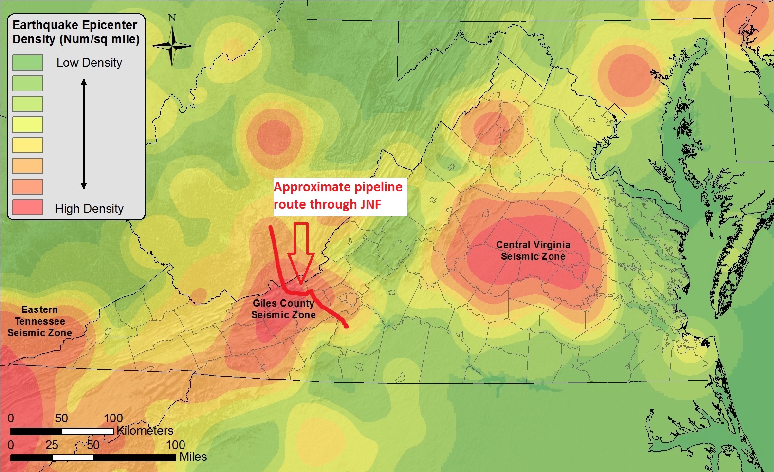
- Failure to mention, map or discuss the potential hazards of the Giles Seismic Zone, scene of the largest earthquake in Virginia history, in the exactly the area the pipeline would cross the AT and JNF. Unlike earthquakes in the Western United States, earthquakes in the East occur deeper underground, tend to travel along mountain ranges, are amplified by mountain ridges, and have serious effects much further away from the epicenter. Effects of the 1897 Giles earthquake were most severe along the Appalachian Mountains and were felt as far away as Atlanta, Charlotte, and the Ohio River between Ohio and West Virginia.
- Failure to note that the proposed route traverses the largest known large rock block landslide in Eastern North America, located on the southeast flank of Sinking Creek Mountain – a landslide that may have been caused by a single earthquake. The US Geological Survey has an entire booklet about this location titled, “The Mountain That Moved” (USGS, 2000).
The developer says that such hazards “are not considered severe and can be mitigated with appropriate construction design.” The Forest Service disagrees, stating that
“the potential for seismically induced landslides is likely the most severe geologic hazard in terms of potential catastrophic destruction of the pipeline.”
Steep slopes? Erosion? Sedimentation? What could go wrong? The proposed pipeline route goes up and down three steep mountain slopes in the JNF: Peters Mountain, Sinking Creek Mountain and Brush Mountain. The potential for erosion and sedimentation is high, yet the developer provides very little information about the dangers or its strategies for avoiding them. For example:
- There is no Project Specific Erosion and Sedimentation Control Plan. The Forest Service notes the recent negative experience with the new Celanese pipeline on Peters Mountain as evidence that frequent erosion and sedimentation inspection is necessary (see photo above) and adds that, “just stating that impacts will be minimized or mitigated does not quantify the effects.”
- The developer is vague about steep slopes, merely noting that “topography varies from flat to slopes exceeding 45 percent.” The Forest Service labels the report “entirely inadequate” and asks for much greater detail, including site-specific drawings for each cut and fill, the exact slope and how it was calculated and a host of other information.
- The developer says sedimentation impacts will be temporary; the Forest Service says impacts will be long-term, and it requires site-specific analysis of impact on waterbodies and aquatic life.
- In a similar vein, the Forest Service requires supporting independent research and citations to support claims that the developer’s construction techniques will be sound and have minimal impact, since “Simply stating things will work does not mean that they will.”
Water and wetlands impacts dramatically understated. The developer takes a casual approach to water issues. For example:
- The developer says in one place that its project does not cross any “riparian corridor” in the JNF, yet another part of the report lists 29 proposed waterway crossings.
- The developer asserts that all impacts to streams will be temporary, but the Forest Service strongly disagrees, noting that this conclusion is “unsupported by quantitate analysis” or “independent scientific analysis.” The developer is specifically required to discuss all short and long-term potential impacts of blasting such as “fracturing aquifers and damaging perched water tables” as well as impact on living things in the waterways.
- Project plans require millions of gallons of water during construction (55 trucks with 55,000 gallons of water per day for 11 crews), but the developer does not identify the water source and claims that no water will be withdrawn in the JNF. Before the authorization for any withdrawal or discharge of water in the JNF, the developer must conduct a very detailed analysis, showing the flows required in each body of water to protect “stream processes, aquatic and riparian habitat and communities, or recreation/aesthetic values,” and they cannot divert water “when diversion would adversely impact same.” The developer claims this rule does not apply to their project, but the Forest Service says, “This is not true.”
- The developer says there are “no liquids in the pipeline that would be released to groundwater or surface water in the unlikely event of a leak.” The Forest Service counters that, “There is an abundance of evidence that condensates of water and organics occur in natural gas transmission pipelines.” They require the company to identify and discuss “all condensates that could form in the proposed pipeline and be released accidentally by a leak.”
- The developer proposes to cross Craig Creek five times, including two times in 500 feet in the JNF. The Forest Service responds that this plan is “unacceptable given impact to stream, riparian and aquatic resources.” Many of us have suspected that someone is drawing the pipeline route using Google maps from an office in Pittsburgh, and planning of this sort certainly reinforces the notion.
- The developer ignores the Federally Listed Fish and Mussel Conservation Plan that applies to several of the water crossings, including Craig Creek.
- The developer plans to run the pipeline 50 feet from the water’s edge in some places and within 15 feet in others. The Forest Service requires a minimum setback of 100 feet, increasing with slope – and this also applies to “intermittent and ephemeral streams, seeps, springs and lakes.”
- The developer ignores the fact that wetlands have the same level of protection in the JNF as perennial streams – a minimum of 100 feet, adjusted for slope.
Impacts on wildlife, vegetation and aquatic resources receive generally ignored. “Woefully inadequate” is the Forest Service’s description of the Environmental Consequences portion of the developer’s report. For example:
- The section on Vegetation, Wildlife and Habitat and Aquatic Resources does not even mention aquatic resources and is very “general and incomplete” about everything else.
- In the 125-foot right-of-way, all vegetation would be removed during construction, much of it mature oak trees on mountain slopes. The developer says the area will undergo “natural revegetation,” but oak trees do not regenerate quickly or easily from seed and, “Given the age, size and condition of many of the uplands sites, coupled with the level of disturbance expected, natural regeneration to current vegetation types is unlikely.” Impacts to old growth communities are likely to be permanent and should be so described.
- The developer did an incomplete analysis of impacts on threatened and endangered species, including golden eagles and cerulean warblers.
As troubling as these reports by the EQT partnership are, there is something even more troubling. The developer produced the reports knowing that experienced, qualified Forest Service staff would review them, yet they still supplied inadequate and incomplete information. They prepared totally misleading evidence of the pipeline’s visual impact on the Appalachian National Scenic Trail, an iconic part of our regional landscape. If they are willing to be this careless or devious (take your pick) about the five miles or so of their project in the Jefferson National Forest, what are they doing in the other 295 miles where private citizens may have their land taken away by eminent domain if the Federal Energy Regulatory Commission approves this project?